
When people think about how to submit planning drawings, they usually picture floor plans and elevations. Yet one of the most common reasons a planning application is held up at validation has nothing to do with the design of the building. It is the site plan: missing information, the wrong scale, an unclear boundary or no north point. Until the council is satisfied that the drawings are complete, the application cannot be registered and the decision period does not begin.
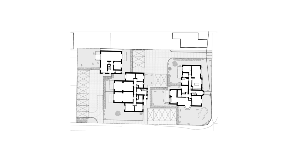
This article focuses solely on the site plan and the location plan that accompanies it, using as a working example the proposed site plan for a residential scheme in Selsey, West Sussex, which we are currently preparing to submit for planning.
Location plan or site plan: what is the difference?
Planning applications usually need two drawings that describe the site, and they are often confused.
The location plan identifies where the site is. It is drawn on an up-to-date Ordnance Survey base, typically at 1:1250 or 1:2500, and shows the application site outlined in red within its surrounding streets and buildings. Its job is to let the council, consultees and neighbours find the site without any doubt.
The site plan, sometimes called the block plan, shows what is proposed within that site. It is drawn at a larger scale, typically 1:500 or 1:200, and shows the proposed buildings in relation to the boundaries, neighbouring properties, access, parking and landscaping.
For the Selsey application, we have prepared both ahead of submission: block and location plans at 1:500 and 1:1250, and a separate proposed site plan at 1:200 on an A3 sheet. The larger scale was needed because the scheme involves several buildings, shared parking and landscaped areas that could not be shown clearly at 1:500.
What the location plan must show
The location plan is the drawing most likely to cause an application to be returned as invalid. As a minimum, it should include:
- A red line drawn around the whole application site, including any land needed for access to the road, visibility splays, parking and landscaping.
- A blue line around any other land owned by the applicant that is close to or adjoining the site.
- Enough surrounding context to identify the site, which normally means showing at least two named roads and the surrounding buildings.
- A north point, a stated scale and the paper size it should be printed at.
- An up-to-date map base, with the appropriate Ordnance Survey licence or copyright notice.
On the Selsey location plan, the site is outlined in red and labelled "the site", with a north point and the surrounding streets shown, so its position is unmistakable.
What the site plan must show
The site plan is where the council assesses how the development sits on the land. The proposed site plan we drew for a project in Selsey shows how each requirement is met.
The site boundary
Every boundary of the site must be shown clearly, and the proposed buildings must be drawn in their correct position relative to it. On Selsey, the boundary encloses three separate buildings, labelled Block A, Block B and Block C, so the officer can see exactly how far each sits from the edge of the site.
Neighbouring buildings
The site plan should show the outline of adjoining buildings, not just the application site. On Selsey, the neighbouring houses beside the site and the buildings across the road are drawn in outline, which allows the officer to judge separation distances, overlooking and the relationship of the new blocks to the existing street.
The proposed buildings
Each new or extended building should be shown with its footprint drawn accurately to scale. On Selsey, the external walls of all three blocks are drawn in heavy line, with the internal layout shown in outline, so the scale and layout of the development can be read at a glance.
Access, parking and hard surfaces
Officers and the highway authority need to understand how vehicles and pedestrians will enter and use the site. The Selsey plan shows the access from the road, the parking bays drawn individually, and the areas of paving between the blocks. Showing parking as individual, correctly sized bays, rather than as a general "parking area", answers a question the highway authority will otherwise ask.
Landscaping and trees
Soft landscaping, hedges and trees should be shown, both existing and proposed. On Selsey, planted borders and hedges are drawn along the parking areas and around the blocks, with trees and lawned areas shown in the gardens. This demonstrates that the scheme provides usable outdoor space and is not dominated by hard surfacing.
Scale, north point and title block
Every site plan must state its scale and the paper size, include a north point, and carry a drawing title and number. The Selsey site plan is drawn at 1:200 at A3 and titled "Proposed site plan", so anyone printing or measuring from it does so at the correct scale.
Common site plan mistakes that delay validation
From our experience preparing planning submissions, these are the issues that most often cause a site plan to be queried:
| Mistake | Why it causes a problem |
|---|---|
| No red line, or a red line that omits the access | The council cannot confirm the extent of the application |
| No north point or scale | The drawing cannot be measured or orientated |
| Neighbouring buildings left off | Separation distances and overlooking cannot be assessed |
| Parking shown as a vague area | The highway authority cannot check numbers or sizes |
| Trees omitted | Root protection and landscaping cannot be assessed |
| Different scales on plan and title block | The drawing appears unreliable and may be rejected |
| Outdated map base | The site may not match what is on the ground |
Check the local validation list before you submit
Each council publishes its own local validation checklist, which sets out any additional drawings or information it requires on top of the national minimum. Some councils expect bin and cycle storage, drainage or visibility splays to be shown on the site plan, and many have their own preferred scales. Checking that list before the drawings are finalised is the simplest way to avoid an application being returned, and it is the final check we carry out on every submission, including Selsey.
Our guides to the residential planning application process and planning drawings versus building drawings explain what happens once the drawings are accepted. If your project is a single new home rather than a larger scheme, our article on appointing a new build house architectural designer covers the earlier design stages.
Book a Consultation
If you are preparing a planning application in Selsey, West Sussex or Surrey and want your site plan and location plan to be right first time, please get in touch with Adamson Architecture & Planning to arrange a free, no-obligation consultation.
Book a Consultation
For expert advice on all your planning and building control requirements, please get in touch to arrange a free, no obligation consultation.